
History
Building Bombay
Historian Prof Aban Sethna talks of the development of the city and the people and institutions that made it great
"Bombay was one big bog … It was no cakewalk for the British. They were badgered by the Dutch, the Marathas, the Portuguese and others. Climatically, "two ‘maussoms (seasons)’ was life of Man.” Even governors and their wives died of malaria, cholera,” noted research scholar Prof Aban Sethna in her lecture and power point presentation on "Bombay: A City Metamorphoses” at the Dr Sir J. J. Modi Memorial Hall of the K. R. Cama Oriental Institute on December 12, 2008.

Prof Aban Sethna: history behind the structures
To survive and trade in that politically and physically hostile environment, the representatives of the East India Company (EIC) ensconced themselves in a Fort they built, on the southeast corner of the then roughly H-shaped Bombay Island. Its 27’ high walls stretched from St George’s Hospital, via the Bazar Gate (the street still bears this name), to the Institute of Science, to the Apollo Gate, somewhere in the vicinity of the Natural History Society Building. It had one gate in the west, Church Gate (where stands Flora Fountain today) named after St Thomas’ Cathedral nearby. "The Esplanade, to the west, stretched from today’s Cooperage to Metro Cinema, maintained without any permanent structure, to provide the defenders of the Fort clear space to fire at the enemy,” Sethna sketched the skeletal beginnings of today’s ‘Maximum City.’
Within the Fort stood Bombay Castle, the administrative headquarters of the British, inherited along with the seven isles from the dowry of Portuguese princess Catherine of Braganza who wed England’s Charles II. "Bombay’s oldest architectural gem is now guarded by the Indian Navy, trifle too zealously (beyond the Asiatic Society, in an area prohibited to the public),” said Sethna.
The untamed Arabian Sea swept in between Worli and Cumballa Hill. Byculla, Bellasis Road, Khetwadi, Pydhoni were under water, effectively dividing Bombay into two halves — northern and southern. Indeed, ‘Py-dho-ni’ was just that — even the governors were known to strip off their shoes and socks and walk across the shallow water, averred Sethna.
To protect themselves from the "menace of the marshes,” and to prevent the sea from periodically submerging Bombay, the EIC launched upon its program of building the causeways that connected island to island. Work on the Hornby Vellard — today’s Annie Besant Road — began in 1721 but the sea taxed the Britishers’ engineering skills again and again. The name of Capt Elias Bates who was in charge of the project provoked foul language as an alarmed EIC was required to spend £ 400 to £ 600 a month. When Bates pronounced the work complete in 1728 and demanded a gratuity, he was not only denied the prize, but slapped with a large fine, said Sethna. So fearful was the EIC of the strength of the sea in the area, that, long after the Vellard was built, no structures except a race course was allowed there, said Sethna quoting the words of Gerald Augier: "This great city has been built by God’s grace.”
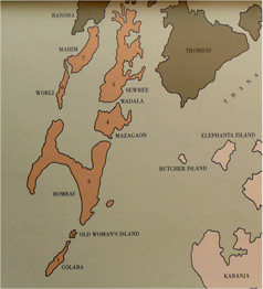
Map depicting seven islands of Bombay
Why this Vellard (Portuguese term for "fence”) stood in the name of Hornby is a mystery, as William Hornby was Governor of Bombay much later (1771-84) and the structure came up for repair in 1785, noted Sethna.
Once the Vellard was in place, the Britishers proceeded with the Duncan-Sion Causeway in early 1800 which ran between today’s Sion Circle and Chunnabhatti and retained its name till 1979. The name is inscribed in Marathi on the garish yellow gates of the municipal sewage pumping station there, said Sethna. Incidentally, it was at the gate of the same pumping station, that Sethna found the ‘IX milestone’ denoting the distance from the center of Bombay, lying in two pieces.
Lady Avabai Jejeebhoy volunteered to build the Mahim Causeway linking Mahim and Bandra, "the queen of the suburbs, dotted with beautiful bungalows and gardens,” when 15 to 20 boats capsized during the monsoon storms in 1841. Jejeebhoy donated Rs 1,55,800 for the project on the condition that no tolls or taxes would be imposed on the users, and buttressed it with a further Rs 2,200 to build a handsome approach from Mahim Bazar to the Causeway, called Lady Jamsetjee Road. Reverend Hebber, Lord Bishop of Calcutta who visited Bombay in 1824-25 found "Sion very beautiful,” but declared Mahim "an ill-built town.”
In 1838 the Colaba Causeway was completed, linking Colaba and Old Woman’s Island to the Bombay Island. Thereafter the ugly name, "Old Woman’s Island” fell into oblivion, stated Sethna.
"The metamorphoses of Bombay begins with the building of the causeways. After that, began the work of infilling and reclaiming low-lying areas,” noted Sethna, adding that work on Bellasis Road — named after General Bellasis — was the first to be built in 1793 with monies raised from public subscription. In 1839 Grant Road came into being, stretching from Chowpatty to Byculla. The reclaiming and infilling of low-lying areas "adversely affected Bombay’s skyline and topography” with extensive quarrying of its hills. In 1862 Governor Bartle Frere signed the demolition orders of the Fort walls; its stones and debris were used, along with night soil and city sweepings, for in-filling of low-lying areas.
As sand was also used for the purpose, the EIC had given the right to a Land Company, to dredge and ferry it to a site in Colaba. Alarmed that their own business might be adversely affected, the night soil carriers wrote to Tabius Princep, secretary to the government, petitioning against it and offering Princep a share in the monopoly, if given them! Sethna told Parsiana in the course of an interview, after her talk, that she had found the reference in the Bombay Times.
The poor people of Surat who flocked to Bombay in the wake of the Surat famine, built Bellasis Road while the roads in Trombay were built by prisoners who had been driven into the debt trap by poverty, informed Sethna. Sir Jamsetjee Jejeebhoy discharged many of their debts and helped to free them, she added.
The Bombay Green — today’s Horniman Circle — was the scene of brisk business in cotton and opium and Sir Dinshaw Watcha has attested to the clattering of cotton screws there.
In 1860 Vihar Lake became a source of piped water for the city.
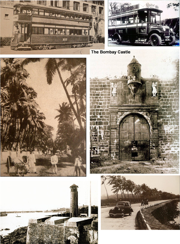
Clockwise from top left: Double decker tram, BEST bus, Bombay Castle, road connecting Cumballa Hill to Worli, watch tower at Fort’s rampart and Mahim Causeway
In 1867 the railway bridges began to be built — Carnac Bridge and Elphinstone Road Bridge. In 1875 Wodehouse Bridge, named after Governor Wodehouse, spanning from Wellington Mews to near Badhwar Park, was built, but was later dismantled. The Bombay Port Trust came up in 1893. The Bombay Improvement Trust was set up in 1898.
As a historian, Sethna regreted that milestones of the city’s development, like name plaques, have been discarded by the roadside. Today the only trace of the Fort Wall is a small bastion near St George’s Hospital.
So much of the city stands on reclaimed land. "Even when the foundation of the University Campus was laid, sand was found. The whole Western Railway is built on reclaimed land.” She provided little vignettes. For example, the Afghan Church was called Bride’s Church. It was renamed in memory of those who fell in the two Afghan Wars. The steeple of the Church guided ships safely into the harbor.
Sethna has taught the History of Art and Culture at the Sir J. J. College of Architecture since the past 33 years. After retiring from there she has been a guest lecturer at the Rizvi College of Architecture. She helps students to integrate the culture of each period of history with the technicalities of its architecture, giving them the socioeconomic background. For example, the Romans were empire builders and gave visual expression to their military conquests by building Triumphal Arches and Victory Columns. "There were 36 Triumphal Arches in Rome, of which only a few survive today. But they tell the tale of the glory of Rome and the might of its emperors,” she told us. For her outstanding contribution to architectural education in the subject of humanities Sethna was presented the Best Teacher Award in the Humanities by the Maharashtra Association of Schools of Architecture (MASA) in 2007.
Married to architect Zarir Sethna ("That’s how I got into architecture!”), the couple have a son, Jamshed, also an architect, and a daughter, Thrity, who works for the French Consulate.
In her one-woman "department” of sociology at the J. J. College of Architecture, Sethna said she felt like a queen. But the daughter of Dr Sohrab Kapadia, a general practitioner and Gool (née Desai) nearly gave up at the very inception. The then 23-year-old Master of Arts in ‘Sociology and Anthropology of Western Cultures’ felt she was making no headway, until one girl came and told her, "After your lectures, things fall into place.” "I very nearly kissed her. But for her, I would have quit!”
◆ ◆ ◆
From the archive