
Readers' Forum
“Partying at the Pole”
In "Partying at the Pole” by Noshir Pavri (Parsiana, September 21, 2012) there is an obvious error, navigationally speaking.
Pavri states that the ship arrived at the Geographic North Pole. The photograph of apparently some sort of GPS (global positioning system) device on board shows the ship’s latitude as 90° North and a corresponding longitude of 65 06.714° E. The latitude of 90° N is a pinpoint through which every longitude passes. In other words, at the Geographic North Pole there is no specific longitude. It could be any one of the 360° that encompass the earth, i.e. any one of zero to 180° E or W longitude. The figures shown in the inserted position indicator (presumably a satellite navigation position indicator) are therefore puzzling at best and in serious error at worst!
At the latitude of 90° N there is no specific longitude. The figures shown on the display would only be possible if the ship was at the Magnetic North Pole... and herein lies another malady! No satellite navigation system can show a ship’s position with reference to the Magnetic North Pole. It just can’t be done. Was therefore the figure of 90° N shown as the ship’s latitude manually fabricated? This can be done.
If anyone can dispute my observation and prove me wrong, I would be delighted to be corrected.
Maybe Pavri can ask his Russian hosts to explain this one... and even claim some form of rebate from the voyage fees!
Cmde TEHMASP R. MOGUL (Retd)
tehmasp.mogul@gmail.com
Noshir Pavri replies:
I get the impression that Cmde (Retd) T. R. Mogul has very limited knowledge and practical experience in the working and use of the GPS. The photo of "some sort of GPS device” he refers to is actually a "Furino,” clearly readable on the top-left of the unit. It’s a world-recognized brand known for its accuracy and reliability, as are other brands such as "Garmin,” "Navman,” etc. They all very clearly and accurately indicate the longitude and latitude of the position they are operated from, in addition to other pertinent data, as programed. This unit was installed on the bridge of the ship and displayed the longitude and latitude of the vessel when she reached the Geographic North Pole.
Mogul is correct in stating that the latitude could be any one of the 360° points that gird the earth, (or 21,600 points if he wishes to split them down into minutes).
He seems to have overlooked the fact that the voyage started from Murmansk, sailed north on the Barents Sea, then set course on longitude 65° E for the Arctic Ocean, heading directly for the Geographic North Pole between the Archipelago of Franz Joseph Land and Sevemaya Zemla. This has accurately been displayed in the GPS reading as being 65.05.714° E on arrival at the North Pole.
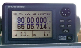
Thus, depending on the point of departure, the longitude would naturally vary with each departure point selected, but the final destination, i.e. the Geographic Pole would be common to all.
I have no idea where Mogul got the impression we were at the Magnetic Pole. He should know that the Magnetic Pole is constantly on the move whereas the Geographic Pole is a fixed point at the bottom of the Arctic Ocean, 1.7 miles deep at that location. But the ship was grounded on the ice cap floating above it. This enormous ice cap is constantly moving in a small circle, but very slowly over very much smaller distances due to the effects of the earth’s rotation and the force of the wind and ocean currents on it. So, although we were at latitude 90° N, there has never been the slightest suggestion we were at longitude zero degrees. When one is standing at 90° North, one has only to look or walk around in a small circle to cover all 360° of longitude.
At 90° North, the longitude is totally irrelevant. You move even a few meters in any direction, and you cross from the Greenwich longitude to the Dateline in the Pacific Ocean. The point is you are at 90° N, so you should not get confused by longitude readings displayed on the GPS.
In addition to the many hand-held units brought by interested passengers like myself to check on progress individually, two of them were very experienced blue water sailors and navigators. If, as Mogul suggests, the ship’s equipment had been manually adjusted to give a false reading, this would have been immediately picked up by any one of us with our own units. None of us would have accepted it for a second.
I utterly reject his insinuation that the ship’s captain, navigator and the expedition leader colluded to blatantly mislead us all by fabricating the GPS readout. I can only say that this remark has been made very irresponsibly and is unbecoming of anyone holding the rank of Cmde, retired or not.
A certificate was issued to all of us at the end of the trip, confirming our arrival at the North Pole, signed by the ship’s captain and the expedition leader, Laurie Dexter. I suggest that Mogul uses the Internet to read about Dexter’s expertise, experiences, achievements and awards earned over the past few decades for his work at both ends of the earth. To say he is held in very high esteem and respect by his peers is an understatement. It is unimaginable that a person of this caliber would be party to such a scam and put his signature on all these certificates as hinted at by Mogul.
A few years back, I spent 30 days on another Russian Ice Breaker in Antarctica sailing on the Southern Ocean, acknowledged to be the roughest and wildest in the world. Coupled with my recent 15-day trip in the northern oceans, these voyages have given me a reasonably good idea and understanding of the oceans, navigation and how magnetic compasses are affected by the Polar Fields. I wonder if the good Cmde had similar experiences during his time in the Indian Navy? His suggestion of asking for a rebate on the cost of this voyage is a total non-starter.
NOSHIR PAVRI
Hong Kong
perinosh@netvigator.com
◆ ◆ ◆
From the archive